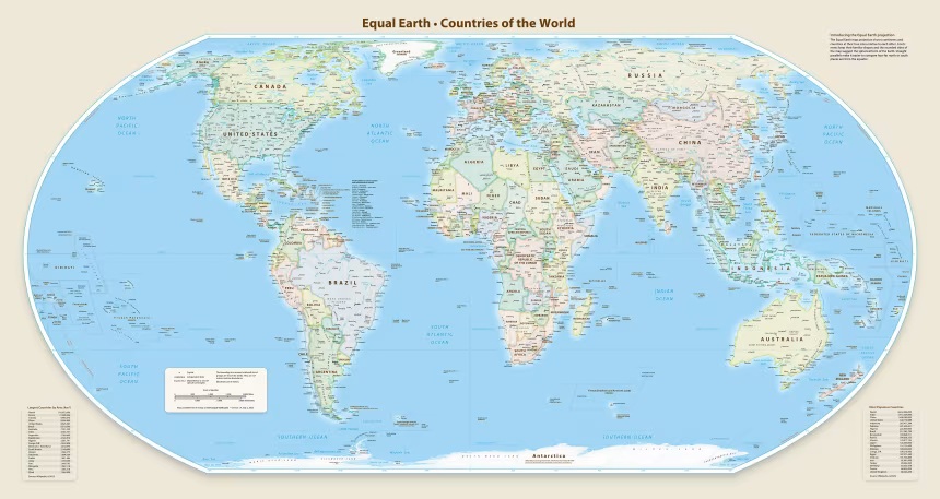
The United Nations General Assembly has voted to adopt a new world map that shows Africa's size more accurately.
The vote came after African countries asked the UN to correct a long-standing mistake.
Togo introduced the resolution to the assembly about a year after the African Union supported it. This resolution is part of the #CorrectTheMap campaign, which has the backing of all 55 African Union member states.
The resolution wants to replace the old Mercator map, which distorts Africa's size, with the Equal Earth projection. This new map is thought to show countries' true sizes better.
It calls for a fair representation of the world’s regions, especially Africa. The resolution argues that the way the world map is drawn makes Africa seem smaller and less significant in people’s minds.
The Equal Earth projection, developed in 2018, is seen as a better way to show countries and continents based on their actual surface areas.
The Guardian reports that it shows Africa much closer to its real scale. On the other hand, the Mercator map, created in 1659, shows Greenland as about the same size as Africa, even though Africa is roughly 14 times bigger.
Historians and geographers have said the Mercator projection is based on Western stereotypes.
Activists have also made similar claims, with some calling it “cartographic colonialism.”
At the UN General Assembly, the resolution passed with strong support. 164 member states voted in favor, including Nigeria, Togo, Ghana, Morocco, and 50 other African nations.

Germany, France, Turkey, and the United Kingdom also supported the resolution. But Hungary, Israel, Japan, Pakistan, South Korea, and Venezuela chose to abstain.
The US voted against the resolution, with its representative calling it “superfluous.”
UN resolutions cannot be enforced, so countries and institutions are not required to use only the new map or banned from using the old one.
Still, this outcome could lead to updates in school curricula and everyday technology, since the Mercator projection is widely used in education, technology, and governance.
Togo’s foreign affairs minister, Robert Dussey, said the resolution highlights the unfair representations caused by the Mercator projection.
“The discussion is not a political discussion but a scientific discussion because there is scientific proof, so we all have to accept the reality,” he said.
Dussey added, “The projection has had lasting cognitive, educational, cultural, geopolitical, and socioeconomic effects, reducing the perceived size of Africa and other regions in the global imagination.”
France also spoke in favor of the resolution before it was passed. The foreign minister, Jean-Noël Barrot, said earlier on Friday, “We will abandon the Mercator projection in favor of map representations tailored to specific uses, more faithful to actual surface areas and in line with the recommendations of cartographers and scientists.”


Drop your comment
No comments yet — be the first to drop the gist 👇